Accurate Dig Site Drawing for Safer Excavations
Print this Article | Send to Colleague
Sher Kirk – Operations Director – Utility Safety Partners
The dig site map on a locate request is the foundation on which the Click Before You Dig process is built. An accurate map is a strong base leading to a safe excavation. If the map is inaccurate, the next steps in the process are built on that false information which — despite checks and balances — can lead to damage or injury.
Statistical analysis indicates that third-party infrastructure damage is less likely to occur when the excavator submits their request for locates online rather than over the phone. This fact points directly to the importance of the accuracy of the polygon on the locate request. The excavator can better identify the dig site by outlining it directly on the map than a USP agent can by interpreting the verbal directions of a caller who cannot see the map from which the agent is working.
Utility Safety Partners’ software uses the dig site drawing to determine which members (registered asset owners) have underground assets in the work zone. Where the polygon overlaps with registered assets on the USP member database layer, those members are notified of the excavation and will respond to the excavator. If a dig site polygon is too small or is not placed in the correct location on the map, it is possible that a member with an asset in the work area would not be identified. This creates a possible scenario where the excavator might begin work without fully understanding the dangers below.
Fig. A – inaccurate map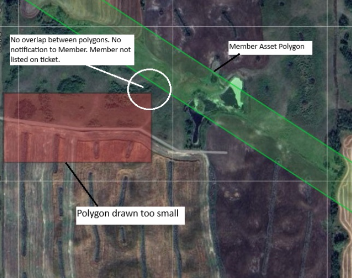
Fig. B – accurate map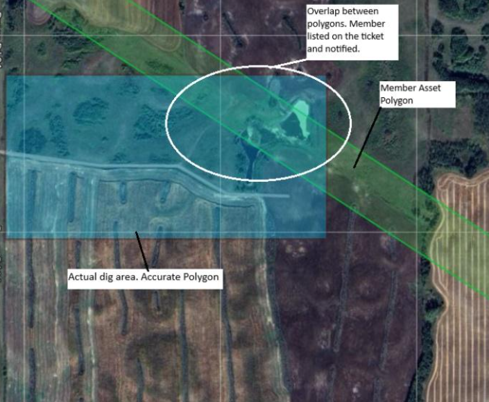
The polygon itself may also be used by asset owners as “electronic white lining” to triage their locate requests by overlaying the shape onto their own GIS records. A member may provide a clearance in error if the dig site polygon was incorrectly drawn.
If you are an excavator who is not comfortable drawing your dig site in the software, USP offers online chat assistance and there are online webinars that illustrate the mapping process.
If you are going to place your locate request over the phone, give the agent as much location information as possible to assist them in drawing an accurate map. Look on Google Maps using satellite view if possible, and you can guide the agent using visible landmarks and distances (access roads, buildings, water features). The most important step you need to take is to check your emailed copy of the locate request to verify the accuracy of the map on your copy of the locate request.
Don’t leave your safety to chance. Check your ticket for accuracy. Never dig outside of the area mapped on your locate request.
